ファイル:Land shallow topo alpha 2048.png

元のファイル (2,048 × 1,024 ピクセル、ファイルサイズ: 1.58メガバイト、MIME タイプ: image/png)
| 解説 |
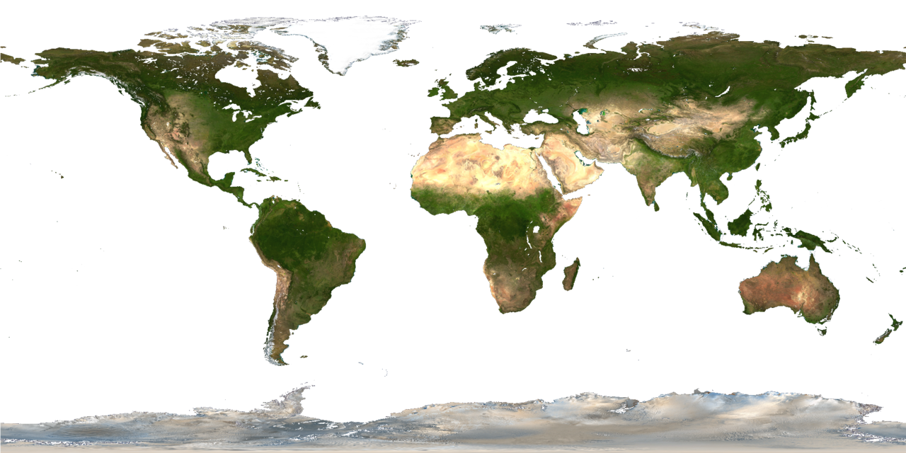
Description from http://visibleearth.nasa.gov/view_rec.php?id=2433 : Credit: NASA Goddard Space Flight Center Image by Reto Stöckli (land surface, shallow water, clouds). Enhancements by Robert Simmon (ocean color, compositing, 3D globes, animation). Data and technical support: MODIS Land Group; MODIS Science Data Support Team; MODIS Atmosphere Group; MODIS Ocean Group Additional data: USGS EROS Data Center (topography); USGS Terrestrial Remote Sensing Flagstaff Field Center (Antarctica); Defense Meteorological Satellite Program (city lights). This spectacular “blue marble” image is the most detailed true-color image of the entire Earth to date. Using a collection of satellite-based observations, scientists and visualizers stitched together months of observations of the land surface, oceans, sea ice, and clouds into a seamless, true-color mosaic of every square kilometer (.386 square mile) of our planet. These images are freely available to educators, scientists, museums, and the public. This record includes preview images and links to full resolution versions up to 21,600 pixels across. Much of the information contained in this image came from a single remote-sensing device-NASA’s Moderate Resolution Imaging Spectroradiometer, or MODIS. Flying over 700 km above the Earth onboard the Terra satellite, MODIS provides an integrated tool for observing a variety of terrestrial, oceanic, and atmospheric features of the Earth. The land and coastal ocean portions of these images are based on surface observations collected from June through September 2001 and combined, or composited, every eight days to compensate for clouds that might block the sensor’s view of the surface on any single day. Two different types of ocean data were used in these images: shallow water true color data, and global ocean color (or chlorophyll) data. Topographic shading is based on the GTOPO 30 elevation dataset compiled by the U.S. Geological Survey’s EROS Data Center. MODIS observations of polar sea ice were combined with observations of Antarctica made by the National Oceanic and Atmospheric Administration’s AVHRR sensor—the Advanced Very High Resolution Radiometer. The cloud image is a composite of two days of imagery collected in visible light wavelengths and a third day of thermal infra-red imagery over the poles. Global city lights, derived from 9 months of observations from the Defense Meteorological Satellite Program, are superimposed on a darkened land surface map. |
| 日付 | |
| 原典 | |
| 作者 |
|
| その他のバージョン |
このファイルの派生的著作物: |
この画像には画像編集が施されています。原本に対して次のデジタル的な変更が行われました。
|
| このファイルはアメリカ航空宇宙局(NASA)によって作成されたものです。NASAの著作権の方針では、特記事項が無い場合、NASAの資料はパブリックドメインとなります。 (詳しくはTemplate:PD-USGov、NASAの著作権の方針について(英語)又はジェット推進研究所(JPL)の画像使用に関するガイドライン(英語)をご覧ください。) |
||
 |
注意事項:
|
元のアップロードログ
This image is a derivative work of the following images:
- File:Land_shallow_topo_2048.jpg licensed with PD-USGov-NASA
- 2006-01-14T15:31:13Z Haham hanuka 2048x1024 (238676 Bytes) http://veimages.gsfc.nasa.gov//2433/land_shallow_topo_2048.jpg [[Category:Earth]]
Uploaded with derivativeFX
ファイルの履歴
過去の版のファイルを表示するには、その版の日時をクリックしてください。
| 日付と時刻 | サムネイル | 寸法 | 利用者 | コメント | |
|---|---|---|---|---|---|
| 現在の版 | 2011年7月4日 (月) 14:01 | | 2,048 × 1,024 (1.58メガバイト) | Martin Kraus | Reverted to version as of 12:30, 4 July 2011 because the later version is worse |
| 2011年7月4日 (月) 12:52 |  | 2,048 × 1,024 (1.6メガバイト) | Martin Kraus | finally removed pixels of shallow waters | |
| 2011年7月4日 (月) 12:30 |  | 2,048 × 1,024 (1.58メガバイト) | Martin Kraus | still trying to remove pixels of shallow water | |
| 2011年7月4日 (月) 12:22 |  | 2,048 × 1,024 (1.58メガバイト) | Martin Kraus | previous upload didn't work, again: trying to remove shallow water pixels | |
| 2011年7月4日 (月) 12:19 |  | 2,048 × 1,024 (1.58メガバイト) | Martin Kraus | set some more of the shallow water pixels to transparent | |
| 2011年7月4日 (月) 12:03 |  | 2,048 × 1,024 (1.58メガバイト) | Martin Kraus | {{Information |Description=|date=4 July, 2011 |Source=*File:Land_shallow_topo_2048.jpg |Date=2011-07-04 12:01 (UTC) |Author=*File:Land_shallow_topo_2048.jpg: NASA *derivative work: ~~~ |Permission= |other_versions= }} {{RetouchedPicture|repla |
リンク
このファイルを使用しているページはありません。
グローバルなファイル使用状況
以下に挙げる他のウィキがこの画像を使っています:
- en.wikibooks.org での使用状況
- GLSL Programming/Unity/Glossy Textures
- GLSL Programming/Unity/Transparent Textures
- GLSL Programming/Blender/Glossy Textures
- GLSL Programming/Blender/Transparent Textures
- GLSL Programming/GLUT/Glossy Textures
- GLSL Programming/GLUT/Transparent Textures
- User:Dirk Hünniger/gsl
- Cg Programming/Unity/Glossy Textures
- Cg Programming/Unity/Transparent Textures
- fr.wikipedia.org での使用状況
- it.wikipedia.org での使用状況