ファイル:Roman Spain - AD 400.png

このプレビューのサイズ: 798 × 600 ピクセル。 その他の解像度: 319 × 240 ピクセル | 639 × 480 ピクセル | 1,022 × 768 ピクセル | 1,156 × 869 ピクセル。
元のファイル (1,156 × 869 ピクセル、ファイルサイズ: 1.14メガバイト、MIME タイプ: image/png)
概要
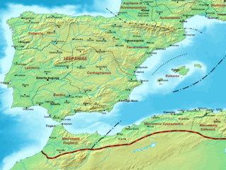
| 解説 | Map of the Roman Empire ca. 400 AD, showing the administrative division into dioceses and provinces, as well as the major cities. The demarcation between Eastern and Western Empires is noted in red. |
| 日付 | (UTC) |
| 原典 |
このファイルの派生元: The Roman Empire ca 400 AD.png: |
| 作者 |
|
この画像には画像編集が施されています。原本に対して次のデジタル的な変更が行われました。
|
ライセンス
この作品の著作権者である私は、この作品を以下のライセンスで提供します。
| この著作物の著作権者である私は、この著作物における権利を放棄しパブリックドメインとします。これは全世界で適用されます。 一部の国では、これが法的に可能ではない場合があります。その場合は、次のように宣言します。 私は、あらゆる人に対して、法により必要とされている条件を除き、如何なる条件も課すことなく、あらゆる目的のためにこの著作物を使用する権利を与えます。 |
元のアップロードログ
This image is a derivative work of the following images:
- File:The_Roman_Empire_ca_400_AD.png licensed with PD-self
- 2011-07-21T13:03:22Z Cplakidas 4339x2689 (11429663 Bytes) fixed Persian border, differentiated between Eastern and Western empire, different borders for praet. prefectures
- 2009-03-21T02:37:17Z Cplakidas 4475x2600 (10476876 Bytes) minor corrections
- 2008-05-29T12:30:03Z Cplakidas 3800x2370 (8491181 Bytes)
- 2008-05-29T12:17:05Z Cplakidas 4560x2850 (11764337 Bytes) clearer version & addition of the Armenian satrapies
- 2007-12-30T02:02:48Z Cplakidas 3380x2120 (6247724 Bytes) added names of dioceses, legend box, various minor adjustments
- 2007-12-13T14:27:35Z Cplakidas 3550x2200 (6970232 Bytes) new improved version made with Inkscape, slight corrections in borders, added several cities in Africa & Spain
- 2007-11-12T19:27:37Z Cplakidas 3550x2200 (4979411 Bytes) minor corrections in southern Gaul
- 2007-11-05T12:58:04Z Cplakidas 3550x2200 (4977196 Bytes) New version, with some corrections & additions
- 2007-10-31T16:55:48Z Cplakidas 3436x2142 (4722554 Bytes) {{Information |Description=Map of the [[Roman Empire]] ca. 400 AD, showing the administrative division into dioceses and provinces, as well as the major cities. The demarcation between Eastern and Western Empires is noted in
Uploaded with derivativeFX
ファイルの履歴
過去の版のファイルを表示するには、その版の日時をクリックしてください。
| 日付と時刻 | サムネイル | 寸法 | 利用者 | コメント | |
|---|---|---|---|---|---|
| 現在の版 | 2013年12月21日 (土) 22:48 | | 1,156 × 869 (1.14メガバイト) | Jbribeiro1 | == {{int:filedesc}} == {{Information |Description=Map of the Roman Empire ca. 400 AD, showing the administrative division into dioceses and provinces, as well as the major cities. The demarcation between Eastern and Western Empires is noted in red.... |
リンク
この画像にリンクしているページの一覧:
グローバルなファイル使用状況
以下に挙げる他のウィキがこの画像を使っています:
- an.wikipedia.org での使用状況
- ar.wikipedia.org での使用状況
- de.wikipedia.org での使用状況
- en.wikipedia.org での使用状況
- et.wikipedia.org での使用状況
- fa.wikipedia.org での使用状況
- fi.wikipedia.org での使用状況
- fr.wikipedia.org での使用状況
- pt.wikipedia.org での使用状況
- tr.wikipedia.org での使用状況